Singapore to Burma Maps
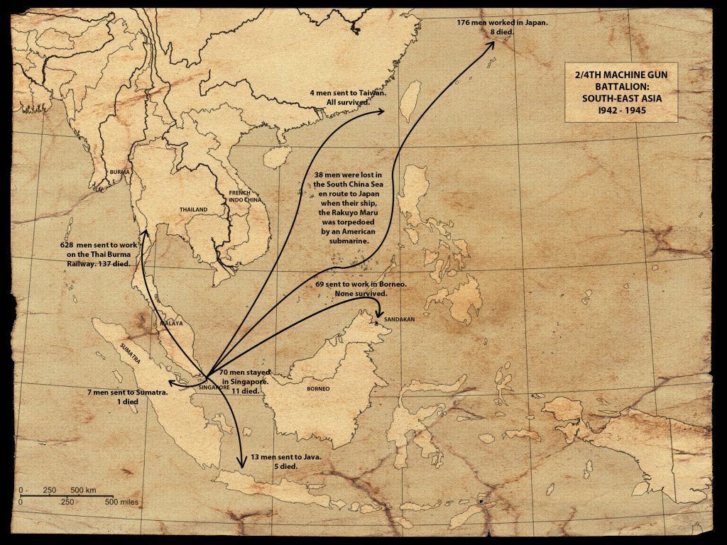
2/4th Movements 1942-1945
 Singapore Camps

Following the capitulation of Singapore those men of the 8th Division that were able to walk, were marched the 17 miles to Selarang Barracks Changi. This Barracks was situated on the north-eastern tip of Singapore on the Changi Peninsula.
At first the Japanese were reasonably lax with their treatment of their new wards and preferred, in the AIF’s case, for the Austalian’s to be autonomous and operate under their own administration. It wasn’t until August that the Japanese began to organize Changi as a POW Camp proper.
The 2/4th Machine Gun battalion arrived at Roberts Artillery Barracks at 0300 hours on the 18th February 1942. Later that day they were billeted out in three bungalows attached to Selarang. There were approximately 192 men from HQ’s Coy 2/4th in house No.38 under command of Capt. “Bob” Phelps, 255 men from ‘A’ and ‘B’ Coy’s in house No.35 under Capt. Tom Bunning and 235 men from ‘C’ and ‘D’ Companies in house No. 34 under the command of the newly appointed Major Colin Cameron.
There doesn’t appear to have been too many complaints at this stage of captivity and as the working parties, the likes of Adam Park group moved out, more space became available. By the time ‘A’ Force moved out all remaining 2/4th had been concentrated in house No. 35.

On 4th April 1942 2800 men of the AIF moved out of Selarang Barracks Changi to Bukit Timah area a vicinity of the MacRitchie Reservoir. The 2/4th had been ordered to supply 300 men for the occasion, under the command of Major Alf Cough. There were five sub-camps in this area being Adam Park, Sime Road, Thompson Road (Caldecot Hill Estate, Mount Pleasant Estate and Lornie Road. Three of the camps were former housing estates and the other two were atap style native hutted camps.
Corporal Stan Currie led a party of twenty-seven men from the 2/4th to River Valley Road Camp on 30th October 1942. River Valley Road would later become one of several transit camps where men who had returned to Singapore would mark time whilst they waited for available shipping before being forwarded to Japan and Saigon. Havelock Road Camp was another camp close by separated from River Valley Camp by a footbridge. There were fifty-nine members from the 2/4th at Havelock Road who would, like the rest of the work parties around Singapore , return to Selarang Barracks in December 1942.
Major Bert Saggers took a party of 278 AIF to Serangoon Road Camp on 25th May 1942. This camp had been an internment camp for the Chinese and consisted of atap huts even less palatial than the Sime Road Camp. This group shared their accommodation with a number of British Prisoners of War employed at the Ford Motor Works.


KILOMETRE CHART OF THE THAILAND-BURMA RAILWAY
PoWs often gave English names to places. Japanese adapted Thai names to their own pronunciation. Several names are given to assist readers.
LOCATION ON RAILWAY 1942-1945 (distances from NONG PLADUK)
000 km NONG PLADUK, Nonpuradukka
002 Konma (transit camp)
005 BanPong. Banponmai
013 Rukke
026 Taruanoi. To Reoa Noi. Talua
039 The Muang, Tamuang. Tamoan, Ta Mueng
041 Tung Tang
047 Kao Din
048 Pak Prage
049 Tung Na Talea
051 KANCHANABURI, Kanburi
055 THA MAKHAM,Tamarkan
(Bridge over River Kwai Yai)
057 Chunghai. Kao Poon, Kapon
069 Wang Len, Wanran, Wun Lung
078 Tapon, Won Yen, Wang Yen
088 Bankao, Bangkao
098 Takiren, Tarkilen, Ta Ki Len
108 Arrowhill, Arruhiru, (Wang Sing)
110 Lum Sum (for waterfall)
114 Wang Po, Wanpo, Wampo (double viaduct)
121 Chong Cab
125 Wanyai, Wang Yai
130 THA SOE, Tarso, Ta Soe
130 NAMTOK (Railway ends 1973)
139 Tonchan (spring camp)
147 Tampi, Tampines
155 HinTok, Hintoku
166 Kanu, Kanyu (several camps)
168 Sai Yoku, Kinsaiyok sub-camps
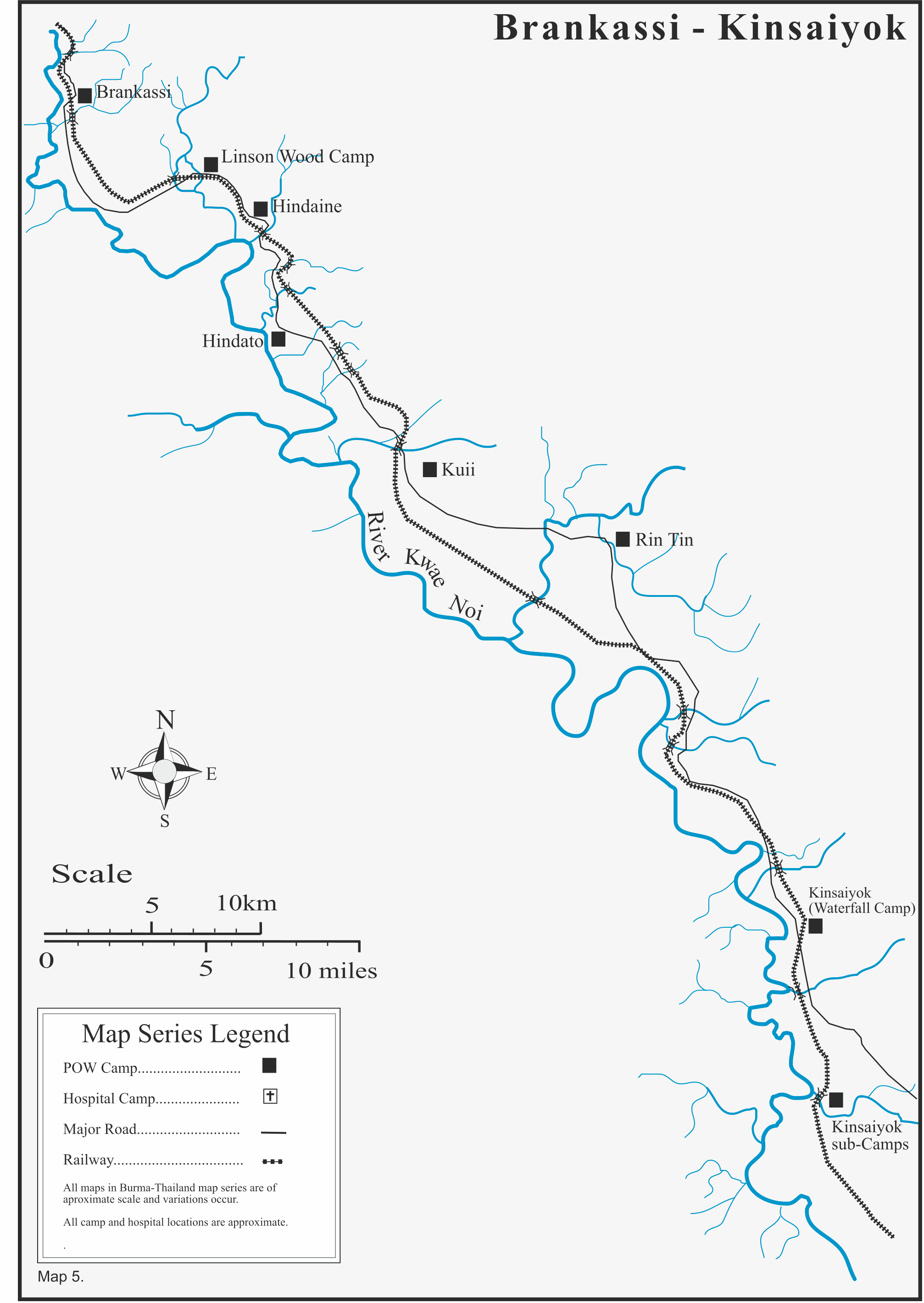
172 Kinsaiyok Main (waterfalls)
181 RinTin, Rinten, Lin Thin
190 Kuei, Kui Ye, Kui Yong
198 Hin Dat, Hindato (hot springs)
208 Brankassi. Purankasi, Prang Kasi
218 Takunun, Dha Khanun, Takanun
229 Namajon, Namajo, Namuchonyai
237 Tomajo, Tamajo, Tamazyo
244 Tamuron Part, Tamuronpato
250 Krian Kri, Kuriankurai, Kreung Krai
258 Kurikonta
262 Konkuita, Konkoita, Concreeta
262.87 MEETING POINT 17thOctober 1943
273 Teimonta, Timontar
282 Nikbe, Nikki, Nike
294 Sinkurai, Songkla, Kenngkluay
THREE PAGODAS PASS
(Thailand /Burma border)
301km Changaraya
311 Anganan, Aungganaung
315 “100 kilo” Camp, Anganan 2
320 Kyando, Kyondaw
332 Aparon, Apalon
Steel Bridge
337 Sparain
343 Mezari, Mezali, Mesali
349 Kami-Mezari, “Upper Mezali”
354 Ronsi, Ronshii
358 Tanzun, Taungzun
362 Tanbaya, Tambaya (“Hospital ”)
369 Anakuin, Anaqueen, Anankwin
375 Bekitan, BekeTaung
385 Repo, Retpu
391 Konnokoi
396 Rabao, Alepauk
401 Tettoku
406 Wegare, Wegale SIN‐TANBYUZAYA
“New Thanbyuzayat”
414.92km THANBYUZAYAT
Burma Base Camp
421 Kuwanra From Moulmein
429 Karuoto, Kawawthut 43km
433 Kamae, Kamawet 38
439 Toku, Tawku 32
453 Mudon 24
453 Menganen 19
461 Pau, Pa-Nuk 11
466 Kokani 6
471.3 MOULMEIN, Morumein 0
BRANCH LINE THANBYUZAYAT TO YE (going South)
THANBYUZAYAT 000 km
Banga 9
Karotshue, Karokpi 14
Anke 19
Tenyu 26
Atsunein 35
Nikkayin 45
Ramayin 55
Karunpe, Taugban 65
Painwan 71
Paraenki 78
YE 86.40
Hellfire Pass Memorial, Thailand-Burma Railway Fourth Edition Australian-Thai Chamber of Commerce 1997